Trying to use google earth to spot some tailing flats. Can anybody give me some tips about what to look for. Maybe examples.
thanks in advance
Rich
Trying to use google earth to spot some tailing flats. Can anybody give me some tips about what to look for. Maybe examples.
thanks in advance
Rich
Short grass=hardbottom and if you find one keep your mouth shut about it
quote:
Originally posted by touchdownShort grass=hardbottom and if you find one keep your mouth shut about it
Better yet, share your information with everyone on this board, the same way they share their information with you!
Robery82, or is that Robbery82? Like you won’t be on his numbers the next time he gets there!
Rich,
Here is a tip for using Google Earth to find flats. Look for a place where you know the water floods by observation, i.e. you drove past it on your boat and you have seen it. Then look for that spot on Google and see what it looks like. Then look around for other areas that look the same. That should get you started…
People will be hesitant to share their flats. I know I spent probably 10 trips scouting around looking (and getting very frustrated and about to quit) before I saw my first tail. And, after all that effort you can be sure I wasn’t going to put the GPS numbers on the internet! Besides, you need to pay your dues before Mother Nature will give up her secrets ![]()
2000 SeaPro 180CC w/ Yammy 115 2 stroke
1966 13’ Boston Whaler w/ Merc 25 4 stroke “Flatty”
www.ralphphillipsinshore.com | www.summervillesaltwateranglers.com
Or you can ask Robbery82 for his numbers! I’m sure he will be glad to share:smiley:
Don’t really want numbers. Just a description of what to look for on google earth. thanks Optiker for a helpful response.
Rich
quote:
Originally posted by OptikerRich,
Here is a tip for using Google Earth to find flats. Look for a place where you know the water floods by observation, i.e. you drove past it on your boat and you have seen it. Then look for that spot on Google and see what it looks like. Then look around for other areas that look the same. That should get you started…
People will be hesitant to share their flats. I know I spent probably 10 trips scouting around looking (and getting very frustrated and about to quit) before I saw my first tail. And, after all that effort you can be sure I wasn’t going to put the GPS numbers on the internet! Besides, you need to pay your dues before Mother Nature will give up her secrets
2000 SeaPro 180CC w/ Yammy 115 2 stroke
1966 13’ Boston Whaler w/ Merc 25 4 stroke “Flatty”
www.ralphphillipsinshore.com | www.summervillesaltwateranglers.com
Good advice, Optiker. I had this same question, and your response sheds some light on where to start.
I have been looking for something like this too. Yesterday, I stopped in at the Round Holiday Inn after work and the tide was super high up in the grass. I thought that it looked like a perfect place for a red to work. Looked at it on GoogleEarth and thought that the area that I had seen looks abundant, almost too abundant. Then I thought about the grass itself…it was the needle like green “grass” and not the sparse stuff I see people fishing at on YouTube. So, I am thinking that there must be a little more to it than simply finding where the water reaches up deep into the grass. I have a inshore trip booked this Friday morning for my son and I. The Cap says that there may be a slim chance for a red in the grass at the very tail end of the trip. I will be paying close attention to not “where” we are fishing, but “why” we are fishing there.
quote:
Originally posted by ls6pilotthanks Optiker for a helpful response.
Rich
You’re welcome. That’s how I roll.
2000 SeaPro 180CC w/ Yammy 115 2 stroke
1966 13’ Boston Whaler w/ Merc 25 4 stroke “Flatty”
www.ralphphillipsinshore.com | www.summervillesaltwateranglers.com
quote:
Originally posted by BlackMagicSo, I am thinking that there must be a little more to it than simply finding where the water reaches up deep into the grass.
yeah, I agree w/ that. I’ve tried this exact thing, and the problem with Google Earth is that somehow all their images seem to be at low tide, in the winter! Makes it pretty much a crapshoot trying to really pick anything out. Maybe a photo intel expert or if you really have a lot of experience, but it pretty much turned into an exercise in futility for me.
To illustrate, below is a Google Earth image of an area I know to have great flats, and I’ve caught tons of reds there. (don’t worry, nobody around here is likely to find it… and if you do, happy fishing!)
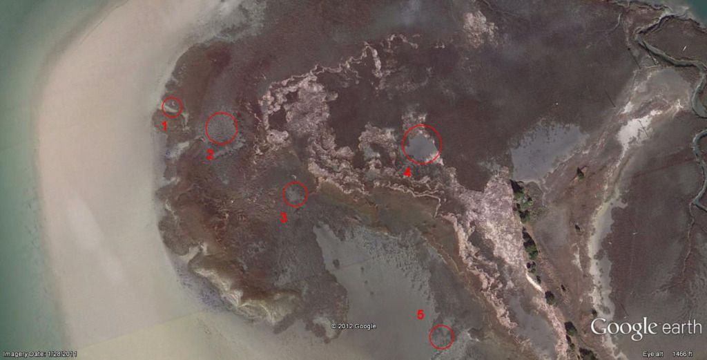
to the left is a larger body of water. I’ve caught fish everywhere circled. (1) is a little cut that leads into the marsh and disappears in the grass. (2)is an open area of marsh grass stubs and mud, only gets a few inches deep even at high tides. (3)is a small area of slightly deeper water (still mud at other than high tide) (4) is a larger, pretty much landlocked “pond” (again, usually dry but somehow they get in there at high tide!) (5) is a point of grass that sticks out into deeper water, grass is covered when flats are accessible but fish seem to stage there, sometimes in large schools.
Hope that helps, but to me this looks pretty much identical to any random section of thousands of miles of SE US coastline. Good luck!
Angler 204 FX
Yamaha 150
I know that spot!
Thanks for taking the time to post something like this.
151 Bulls Bay 40 Yams
Hittn Bottom