Does anyone know any iPhone apps that work well for marking and storing saltwater, inshore fishing points when out on the water and then you are able download them to your computer later? Also does anyone know a decent app that performs navigation, stores tracks, and shows tide data? Free or paid apps?
I currently use the Trout Stream GPS iPhone app to mark my fishing points. It works great in the fact that I can mark my location accurately and then type a detailed note to go with it. But I cannot download the waypoints to my computer where I can save them to an excel file or view them on a larger map.
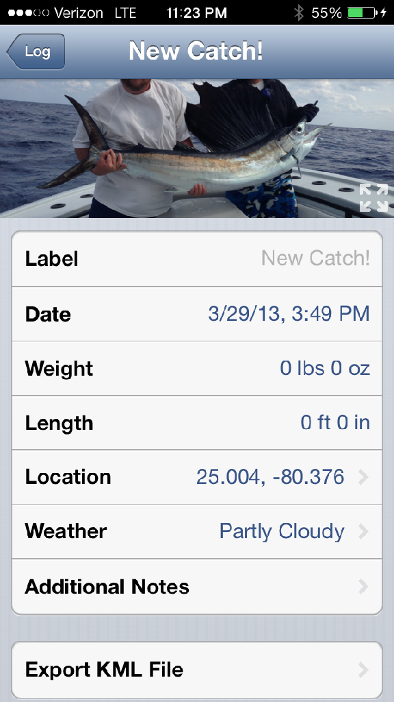
I use one called fish logger . Take a picture of your fish and load it into the app it will save GPS location ,weather and such you can also add notes … It has an option to export KML file off the entry via e-mail .
Here’s a screen shot from my phone with a sail i caught in islamorada .
I agree with tigerfin. The navionics app is by far the best. The chart data is updated once per month and the data comes from other depth finders using the navionics SD card. You just need to start up the app while on wifi before your fishing trip. Currently my iPhone has better chart detail than my two year Navionics HotMap SD card in my lowrance. Being new to inshore fishing I can’t navigate without the app
I broke down and bought the Navionics app and it is downloading now. I say “broke down and bought” because a $10 app seems expensive?but It’s definitely a lot cheaper than a new mounted GPS!
Markingle, why do I need to start the app in wifi before the trip. Once I leave the house, my phone won’t be connected to wifi anymore. Do you mean to just ensure that my GPS is running in the background before I go on the trip?
Stokes - Sorry I was not clear?.since the chart data from Navionics is updated once per month I make sure I have the current map data by starting up the app at home. The app checks for map updates automatically on startup. If there are updates it prompts you for permission to install?hope this make sense. If you do it over a cellular connection you pay for the data transmission.
The purchase includes one year subscription to the map updates?on expiration I think you pay another $10. also I think the iPhone app now cost $15 bucks
seawest - the $50 app is for the iPad. I don’t think its worth it based on what I have been able to accomplish with my iPhone.
Example - I was able to determine the approximate location of the Grillage to avoid losing my anchor! I did this with the iPhone app…
One more recommendation - the app will drain your iPhone battery if you leave it running. I purchase a solar panel from Academy Sports and it works perfectly?at least when the sun it out! some radios have USB though
So I have downloaded the Navionics app and have begun to hand type all of my gps coordinates into it that I had stored on my Trout Stream GPS app. Will be worth it in the future though when I find new spots and can easily export them from the Navionics app to my computer.
I do have one question though. Is there a way to turn off the water contours and other layers so that I can just see the arial map image of the water? I like to be able to see the “real life” marsh lines and other geographic water features like how you can see the land images on the map.