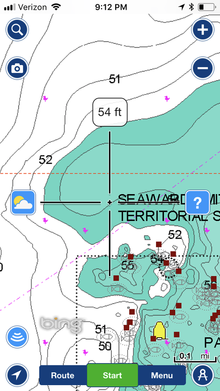
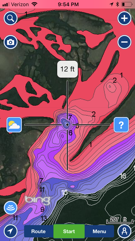
Just putting this out there as an fyi. A new feature for the boating app on my phone and ipad is the ability to target specific depths using colored depth shading for different ranges. It has really been a great tool for scouting those “off the beaten path” deeper water holes around our nearshore reef areas. As we all know, the open ocean on the charts is full of numbers and contours, especially using the 1ft contours of the sonar charts. What this feature has allowed me to do is highlight specific depth ranges to quickly pick apart my targeted areas. Great inshore as well of course. Been a great tool lately! Tight lines and cheers!
Navionics boating app. It does have a free 2 week trial, which at the end of (if you like) you will have to pay for the 1yr subscription. Fory my iphone it’s only $9.99. Well worth it for what I use it for.
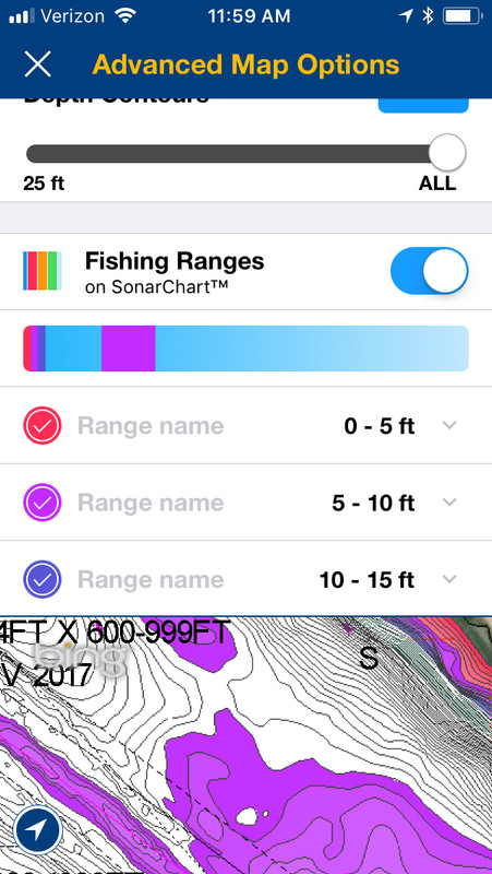
I’ve got Nav+ and I cant find this feature. Did you subscribe to something more? Assume it would be under Map Options menu? Mine only lets me shade out to 60’ and contours and depth details missing past 30’.
Very nice. You have to have the the updated versions. This is a direct result of navionics being bought by garmin. Color shading is available on garmin units.
I tried very hard to use the app yesterday while fishing to target a specific hole I found exploring the app. I could not find anything resembling what the app showed in 200 yards in each direction from where it said it was…I was very hopeful and then very disappointed.
I tried very hard to use the app yesterday while fishing to target a specific hole I found exploring the app. I could not find anything resembling what the app showed in 200 yards in each direction from where it said it was…I was very hopeful and then very disappointed.
Wadmalaw native
16’ Bentz-Craft Flats Boat
I’m with you there. I’ve used it a ton and its not uncommon to have an inaccurate depth on the app. For example, the other day I was in 30ft of water where it said was 1-2 feet…I will still use it a lot but just kinda have to take it with a grain of salt.
The navigational and sonar chart depths are pretty spot on for just about everywhere I boat and fish. That said, these are “aids to navigation”. When these charts are put to use, whether that be on your gps chartplotter or your smartphone via app, they are excellent tools. As far as inaccuracies, I am constantly using sonar chart live and getting the most accurate sonar depth contours for my maps. These will go into updates and improve the map where there might be an inaccurate reading.