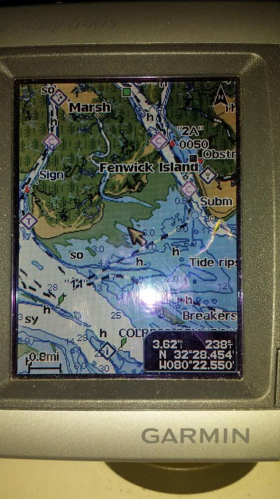
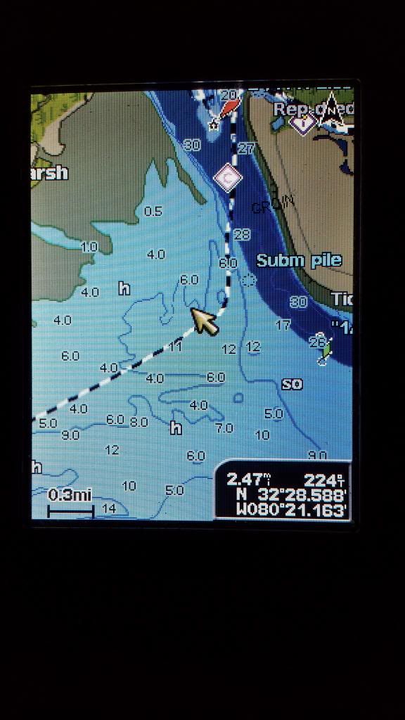
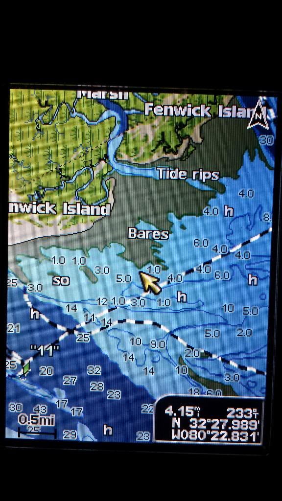
Does anyone have coordinates they would like to share to front side of Otter Island from Edisto at low tide. I have been over there several times in my kayak and now have a bay boat and would like to fish that area. I know that channel changes quite a bit and I have seen boats go over at low tide with no problem
Thanks in advance Steve H
I do not have the coordinates with me. You are correct on going at low tide. It’s helpful to have a GPS to stay in the chanel. I don’t reccomend going on a low tide close to sunset. If you get stuck and the next high tide is a few hours after sunset…Otter can be a cold dark place to sit for 3-4 hours. I speak from experience ![]()
You have to line up a feature on Edisto Beach with a feature on Otter Island. I can’t recall what they are but I would probably go to Google maps and look for some features that align with the channel.
2000 SeaPro 180CC w/ Yammy 115 2 stroke
1966 13’ Boston Whaler w/ Merc 25 4 stroke “Flatty”
www.ralphphillipsinshore.com | www.summervillesaltwateranglers.com
President, Summerville Saltwater Anglers
quote:
Originally posted by OptikerYou have to line up a feature on Edisto Beach with a feature on Otter Island. I can’t recall what they are but I would probably go to Google maps and look for some features that align with the channel.
2000 SeaPro 180CC w/ Yammy 115 2 stroke
1966 13’ Boston Whaler w/ Merc 25 4 stroke “Flatty”
www.ralphphillipsinshore.com | www.summervillesaltwateranglers.com
President, Summerville Saltwater Anglers
Head out of Edisto towards the “A” can…Line yourself up between the water tower on Edisto and the inlet going into otter and you should be good to go…
“Endeavor to Persevere.
Give,Give… Never Take.”
EC
Thanks for the advice fellows. Pescazoro, I knew at one point the water tower was used as a gauge, but was thinking the channel has changed since.
I was just through there Saturday. All the way on the St. Helena side it got pretty low. I was kicking up sand for about 100 yards, then it dropped 9-10 ft swiftly. You could see the cut clearly, it’s pretty narrow, maybe 100 yards wide. We did have negative tides and it was close to dead low.
I usually go up the edisto and through the cut. I can cruise 45 that way and it’s a whole lot less stressful than wondering if I am going to get hung up.
Hydra-Sports 22 Bay Sport
225 Rude
14’ Stumpnocker
15 Rude
Mattr sent you a PM
Where exactly is the “A” can that I see people referencing ?
Thanks,
Greg

Striper7,
It is the green buoy shown on your map.
ok, I’m confused, why not just go up through ■■■■■■■ cut and come back down, instead of trying to beach your boat by accident?
'06 Mckee Craft
184 Marathon
DF140 Suzuki
Greg, if you kinda draw an imaginary line from the green A can to the creek opening to the upper, left, you will see that the creek opening points almost exactly toward the A can. That’s what we are talking about.
tigerfin, they are talking about getting to Fish creek that is between Pine and Otter islands.
2000 SeaPro 180CC w/ Yammy 115 2 stroke
1966 13’ Boston Whaler w/ Merc 25 4 stroke “Flatty”
www.ralphphillipsinshore.com | www.summervillesaltwateranglers.com
President, Summerville Saltwater Anglers
Thanks…I thought it was the green one but I wasn’t sure. One more question for you experienced Edisto boaters. I’m bringing my 18ft Tidewater Down in August and would like to do a day trip to Beaufort. I’ve looked at charts and I have a GPS so I’m pretty sure I can get there. My question is…when I come out of Big Bay Creek to head up the South Edisto, do I need to hang a left and head down toward that marker, hang a right around it and head up the river to avoid any sandbars when I head out of the creek ? I just don’t want to ruin my vacation !
Thanks,
Greg
Yes. Come out of big bay, stay on the beach side til you get to the marker, then swing up.
You can make an immediate right at about a 45 degree angle, get on plane and run through. There will be about 2’ of water there at low tide. You can putz through there and make a breadcrumb trail for future reference. To be on the safe side though, go to the marker, cut up the river.
Straight out of the creek is a big old sandbar with about 8" of water at low tide.
Hydra-Sports 22 Bay Sport
225 Rude
14’ Stumpnocker
15 Rude
Thanks everyone for the info. I appreciate it !
Good advice from MattR for anyone new to Edisto for sure. Once you get your bearings you can cut the corner but only if its high tide.
2000 SeaPro 180CC w/ Yammy 115 2 stroke
1966 13’ Boston Whaler w/ Merc 25 4 stroke “Flatty”
www.ralphphillipsinshore.com | www.summervillesaltwateranglers.com
President, Summerville Saltwater Anglers
Why not go up the back way up fish creek!
I think I got the route. I went from no. 11 can in the sound and went straight for the water tower in Edisto. This was at 9:30 today which was +5.8 in the tide. The lowest I saw was 9.2 and that was on the St. Helena side for maybe 50ft. Most of the trip was 10-12ft. There was a good 1.5ft chop. So at 0 tide you should have 4-7ft in this route. Even with this info at low tide I will still run up the creek to the cut.

Edisto side where I made my cut up river

No. 11 can where I started

Hydra-Sports 22 Bay Sport
225 Rude
14’ Stumpnocker
15 Rude